Building GWR
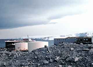
 The site prep, foundation and shell of GWR happened in the summer of 1968-69...the photos you see here are from the late summer and winter. Above, the first slide of the series, before the south side and roof are fully enclosed (NOAA original photo). | |
 Next, a couple of photos from uphill a bit towards where Clean Air and T-5 later happened (NOAA original photo). |
 A view from a slightly different angle on a beautiful day, with the icebreaker Edisto in the background (NOAA original photo). |
 Here's a sunny day view to the southwest across Bonaparte Point. The rock crusher is to the right of the crates (NOAA original photo). |
 Another day, here's another view of the rock crusher, the boomed-down crane with jib, and the back side of GWR (NOAA original photo). |
 Looking the other way from behind the track loader seen in the above right photo (but without the crane). The PAGEOS camera housing is back behind GWR (NOAA original photo).  Here are some of the construction camp Jamesway structures in amongst the construction materials and debris that has been the focus of many of a cleanup over the year. I'm guessing that the stray rock from the blasting operations went through the roof of one of these structures. Although from this distance I can't place the location of this scene on station (NOAA original photo). |
|
 Looking up at the new building from down near the seawater intake...and a met station (NOAA original photo). |
 The view from a slightly different angle. The place looks strange with all the extra rocks and without the utilidor (NOAA original photo). |
 A bit closer to the met station and maybe with a different lens...revealing the original fuel tank logo (NOAA original photo). |
 From behind GWR, looking over the seawater intake and construction debris, toward Torgersen Island (NOAA original photo). |
 Much later, probably toward the end of winter, here is a view of the back of GWR with the generator stacks installed (NOAA original photo). All of these photos are from the NOAA photo archive, specifically from the geodesy collection, taken by one of the four U. S. Army Topographic Command folks, Edward J. Davis, David R. Messent, John H. Page, and John E. Webb, who wintered in 1969 dealing with the PAGEOS project. Note that the image quality of the original slides was not the best, due to a combination of the lighting conditions and the film deterioration. I've done the best I could to improve these images, and I've included links to the original NOAA photos. | |