Palmer Station Timeline
The Beginning Through 1975
Summer 1819-20
Fabian von Bellingshausen, an Estonian and captain in the Russian Navy, had circumnavigated Antarctica following Cook's charts in 1803-06. In 1819, with the vessels Vostok ("East") and Mirnyi ("Peaceful"), he sighted the continent (1/27) near the present SANAE Station site, although at the time he didn't realize the significance of what he had seen. He later discovered Peter I Island and Alexander Island, then thought to be part of the continent. More about Bellingshausen (unless noted, these early explorer links take you to the historical sections of Gary Pierson's south-pole.com polar philatelic site).
Also in 1819, Edward Bransfield headed south in the Royal Navy ship Williams to explore the South Shetland Islands, which accompanying navigator William Smith who had first discovered them the year before. Bransfield sighted the Antarctic Peninsula on 1/30, 3 days after Bellinghausen's first look at the continent.
Summer 1820-21
20-year-old American sealer Nathaniel Palmer's second trip to the South Shetland Islands was in 1920, as part of a fleet of sealing vessels from Stonington, CT.
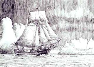
Palmer was looking for fur seals aboard this 47-foot sloop Hero. The vessel had a crew of five, including Peter Harvey, the first black to venture this far south. After anchoring in Deception Island, they observed Trinity Island to the east--and beyond, the mountains of the Peninsula (11/16). Palmer later claimed to be the first to have seen the continent, and he named his sighting Palmer Land. The illustration is copyright © 2004 by the Stonington Historical Society, Inc.; more information from them about "Captain Nat" (archived page).
Summer 1831-32
British explorer John Biscoe, with ships Lively and Tula, sights Anvers Island (then presumed to be part of the mainland), 2/21. He names Mt. William for William IV, then king of England. Biscoe was sailing north after discovering Adelaide Island. Biscoe claimed it all for Britain.
Summer 1897-98
The Belgica expedition, led by Adrien de Gerlache (and with Roald Amundsen and Frederick Cook aboard) charts and names Anvers Island along with Brabant, Liège, and Wienke Islands during January and February as they head south.
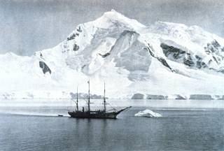
At left, Belgica is off Mt. William, a few miles east of the Palmer Station site. This photo was probably taken about 1 February 1898. Later Gerlache headed southwest into the Bellingshausen sea, where Belgica was to become beset for the winter at about 72°S-85°W. The ship was not freed from the ice until March 1899. Anvers Island is named for the province of Anvers, Belgium (more about Gerlache from south-pole.com). This photo is from the NOAA photo library.
Summer 1903-04
French explorer Jean-Baptiste Charcot, in the vessel Français,, sails down the Gerlache Strait and past Wiencke Island, from where he sees and names Mt. Français on Anvers Island, probably about the same time he found and named Port Lockroy (2/19) on Wiencke Island. He continued south, wintering his ship near Booth Island. At some point this venture also entered and rough-surveyed Arthur Harbor. Charcot returned to the area in 1908-09 with the Pourquoi Pas? later sailed south through portions of the channel east of Adelaide Island, further delineating that island. (more about Charcot from south-pole.com).
1934-37
British Graham Land Expedition (BGLE), led by John Rymill, spends 2 years in the neighborhood
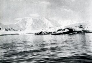 Mt. Français on Anvers Island (9258', the highest peak in the Peninsula region), as viewed by the expedition, probably from the southeast side of Anvers Island north or east of Port Lockroy. The low-budget venture had a shore party of nine, plus seven men aboard the 103-foot former French fishing schooner renamed Penola. The group spent the first winter on Winter Island (named by them) in the Argentine Islands group, on what later became the site of Faraday/Vernadsky. The 1936 winter was spent on Barry Island (also named by the group) in the Debenham Islands in Marguerite Bay; the site was later occupied by the Argentines' "General San Martin" base in the 1950s. The expedition made extensive sledge journeys and flights which went a long way toward proving that Graham Land (the Antarctic Peninsula) was in fact a peninsula (photo by expedition biologist Brian Roberts, from John Rymill's Southern Lights, the Story of the British Graham Land Expedition, copyright copy; Mrs. John Rymill, 1938). More information on the BGLE from the Scott Polar Research Institute.
Summer 1954-55
Falkland Islands Dependencies Survey (FIDS) Base N, Anvers Island, established north of Arthur Harbor (28 February).
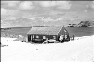 The crew arrived from the UK via Port Stanley on the M.V. Norsel--a Norwegian sealing vessel previously used by the 1949-52 Norwegian-Swedish-British Antarctic Expedition (BAS information). A lot of work was required to erect and finish this hut before winter.
6 men wintered here during 1955 and 1956, and five in 1957--doing geology and surveying--and looking for further signs of copper ore reportedly found near Copper Peak. Meanwhile, Arthur Harbor was named for Oswald Arthur, governor of the Falkland Islands. This photo is copyright © Natural Environment Research Council British Antarctic Survey 2004; (more information from BAS).
Summer 1955-56
First ascent of 9,055'/2,760m Mt. Français (7 December) by FIDS 1955 winterovers Jim Rennie, Arthur Shewry, and Bill Hindson--thanks to Jim for this information!
Summer 1957-58
Base N closed (10/1), no copper ever found. Intermittent summer use of the hut and glacier airstrip would continue.
Summer 1961-62
The Falkland Islands Dependencies were officially renamed "British Antarctic Territory" (3/3), so concurrently FIDS is renamed "British Antarctic Survey" (BAS).
Summer 1962-63
USNS Eltanin, first exclusive NSF Antarctic research vessel, converted from a cargo ship, begins 15-year program (June).
DePaul University biologist Mary Alice McWhinnie makes her first visit to the Antarctic aboard the Eltanin (Cruise 6, 24 November-23 January) studying "The relation of water temperature to the physiology of molting crustaceans."
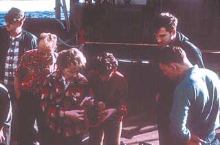
Mary Alice McWhinnie was accompanied by her research assistant Phyllis Marciniak; the two were the first women to work in the Antarctic aboard the Eltanin. Cruise 6 visited the Bransfield Strait and the South Shetland Islands. The two women also were aboard Cruise 7 (4 February-19 March) which worked in the Weddell Sea and off the South Orkney Islands. Cruise 7 also included two women scientists from the University of Chile, Drs E. Figetti and D. Frelen. Here are the cruise descriptions from the Antarctic Journal as well as credits and and more information.
Icebreaker USS Staten Island conducts preliminary survey for proposed Peninsula research station. 26 sites were visited, some more than once, and others were investigated by air, between 18 January and 5 March.
Summer 1963-64
U. S. Secretary of the Interior approves renaming of the Antarctic Peninsula (21 February); this international agreement ends the dispute over Palmer vs. Graham Peninsula.
Further detailed study of Anvers Island undertaken by the Coast Guard icebreaker Eastwind.
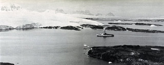 More specifically, this involved a 4-man team from NMCB 8 (including the then-junior officer Joe Henley who later was my supervisor at the Washington DC Navy Yard when I showed up there as a junior officer in 1972); the Norsel Point site is selected for the first station, while other sites are also examined. Here are the details and photos of the survey activity.
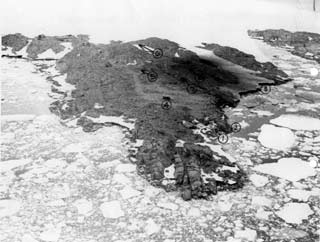
At left, a marked-up aerial photo of Gamage Point with proposed locations for some of the permanent station facilities. Here is the legend, more info and another aerial view.
Summer 1964-65
USS Edisto arrives with NMCB-6 Seabee construction crew to build the first Palmer Station (12 January).

The crew made short work of the new building, with help from the Edisto crew and the winterovers. Here are the construction photos...
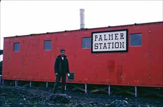
...and here is more information about what we now call "Old Palmer," as well as more photos.
Palmer Station dedicated in a brief ceremony on 25 February 1965.
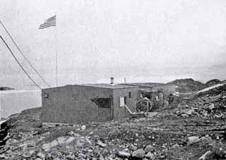
This was 3 days before the Edisto headed north for the last time. Here's a detailed article about the dedication and the science prospects for the new station.
Meanwhile, the old BAS hut was converted into lab space for biology and glaciology and...

...the radio shack. Behind the station can be seen some of the storage and huts left over from the construction. And of course Norsel Point stretches off in the background. This rare photo showing OP and the BAS hut was taken by w/o Jack Cummings who ran comms from the BAS hut attic. Here are several more of his excellent photos.
Winter 1965
CPOIC: HMC C. X. Axworthy, population 9 (list and photos)
Glaciology project included icecap movement stakes and a camp Jamesway erected 8 miles inland--it quickly was buried.
Summer 1965-66
An unannounced visit from a Chilean naval vessel surprises the station.
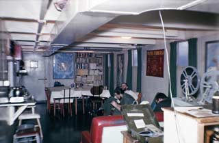
As the story goes...from the Palmer Station logbook.
Everyone on station was waiting for the movie to start.
There was a knock at the door.
Winter 1966
CPOIC: HMC Donald Skelly, population 8 (list and photo).
Winter glaciology continues: 22-foot snow accumulation at the furthest inland snow stakes (2500' altitude). One man is trapped in a storm and forced to dig a snow cave for the night
VX-6 flies photo/recon mission over the Peninsula and station (8/11) but airdrop is cancelled due to low cloud cover.
Summer 1966-67
New station construction begins...the pier was completed along with the fuel tanks and distribution piping, 70% of the seawater intake excavation, and the Biolab foundation and subfloor. The construction crew at the end of the season was 26 Seabees of NCBU 201.
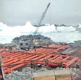
Here's the nearly completed Biolab foundation near the end of the construction season--an intense effort by a platoon of Seabees supported by the Coast Guard icebreaker Westwind. Here are TWO pages of construction photos and details.
Winter 1967
CPOIC: CEC Richard Campleman, population 9 (list and photos).
Winter projects included glaciology/meteorology (Ohio State University) and parasite studies (Virginia Institute of Marine Science).
Summer 1967-68
Biolab construction completed, incredibly, in only 4 months!
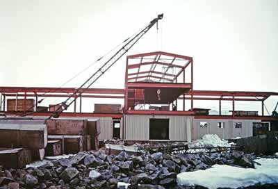
The construction was completed by members of Platoon Alpha of CBU 201, some of whom had also been on station the previous summer when the pier, fuel tanks, roads, and Biolab foundation had been completed. As a construction person who was later involved with Palmer, I am extremely impressed that this structure was completed successfully despite difficulties...by Seabees (disclaimer, I'm a Seabee veteran) (the photos and details).
Palmer Station (the Biolab as we know it now) occupied and formally commissioned (20 March).
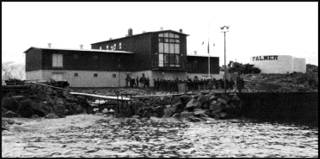
In addition to the completion of the Biolab, (this year's construction included the antenna farm and fuel lines. The 10,000 square-foot Biolab building originally held 2 100kw D333 generators as well as extensive machine shop and storage space for Hero's spare parts and supplies. The power plant was designed to provide shore power for Hero. Here's the article about the station commissioning, along with photos of the ceremony.
3-year OSU glacier study concludes that the Marr Ice Piedmont is in equilibrium, or perhaps expanding slightly.
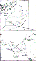
The study included extensive monitoring of ice thickness and movement; the diagram at left illustrates the survey profiles. Art Rundle, author of this paper (Antarctic Journal, September/October 1971) wintered in 1965 and 1966. He concluded that the glacier may have been expanding over the previous 150-200 years, after a period of marked recession. Of course what is of interest today is the extensive amount of field work conducted in dangerous areas many miles from the station--places that have been off limits and untraveled for much of the time since this study was conducted.
Winter 1968
OIC: LTJG William V. Kelly; population 9 (list).
R/V Hero launched in South Bristol, Maine (28 March).
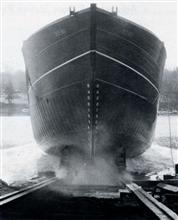
The launch was well attended and documented...here's the March/April 1968 Antarctic Journal article with more pictures.
First (of many!) tide gauges installed at Palmer (April). Normal diurnal variations were observed as 1.2 m, with a maximum of 1.5 m.
Biolab equipment setup continues.
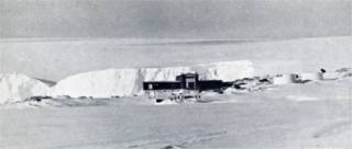
A winter 1968 photo by SSL Ted Gannutz (Antarctic Journal, March/April 1969). Winter science the first year included respiration and photosynthesis studies of lichens and mosses, while lab work in the new aquaria included fungal and algal cultures.
Data collection equipment seriously damaged by power failures.
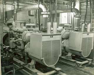
An undated photograph of the original power plant--2 Caterpillar D333's in the back end ground floor of Biolab, each rated for 100 kw...plenty to supply the single building as well as some shore power for the Hero. (more info and photos).
Argentine Beaver aircraft lands on glacier (8/9) as part of BAS medevac operation from Argentine Islands; the Beaver crashed at the Argentine Hope Bay station the next day while attempting to take off with the patient and doctor. There were no casualties, and later in the month a helicopter from the Argentine icebreaker San Martin completed the medevac (and brought mail to Palmer).
After fitting out was complete, Hero completed a 3-week shakedown cruise in the North Atlantic in August.
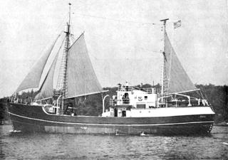
Hero visited the Davis Strait and Baffin Bay, where she supported biologists from the University of Maine (left, Hero is off the New England coast). Off Baffin Island she operated in pack ice. She then went to Woods Hole where the work boat (Heroine?) was taken aboard. Next stop, the Washington Navy Yard for official and public display. Then off to Miami, trawling along the way for the Bureau of Commercial Fisheries. In Miami, Hero was thoroughly inspected before continuing south (photo and information from the Antarctic Journal, September/October 1968).
Summer 1968-69
NGA solo pilot Max Conrad shows up at Palmer (12/21) in his twin-engined Piper Aztec
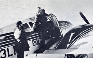
Max arrived from PA on a planned round-the-world flight; he'd already crossed the North Pole. He spent 2 days on station repairing landing gear with help from the station crew. Here he is seen leaving Palmer for Adelaide Island on 12/23, with plans to continue to Byrd, Pole, and McMurdo. But after reaching Adelaide, he called off the mission for this season and returned to PA via Deception Island (photo by Edward K. Mann). (the Max Conrad pages)
Hero arrives at Palmer the first time (12/25 GMT, 12/24 ship's time, EST)
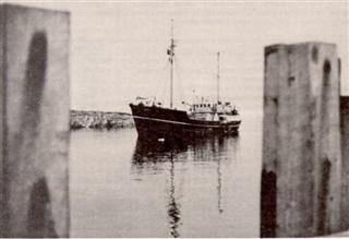
The first season's activity included fishing and collections of liverworts, midges, mosses and sea spiders. Supported scientists included Art DeVries, who was studying the blood-freezing point of several species of cod, and Ian Dalziel's party who studied the geology on Livingston Island. Hero also supported studies of the aftereffects of the recent Deception Island volcanic eruptions. Hero worked in concert with the icebreaker Edisto; normally Hero would cross the Drake at the beginning of the season and remain based at Palmer throughout the summer season, as samples were brought back to the lab for study. Palmer-based research included studies of life in the intertidal zone.
GWR foundation and building shell constructed
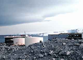
It actually was a rather rough construction season for the Seabees from CBMU-201. First, a fire caused by a faulty heater destroyed the 24-section construction camp Jamesway (18 December) with no injuries but loss of all personal possessions/clothing. And toward the end of the season, a blasting accident in March sent a boulder through the air 100 yards to crash through another Jamesway roof--it hit the Seabee OIC LT Harry Anderson in the head while he was drinking coffee. A medevac was required but he recovered. In addition to the GWR work the helo pad (runway matting) was built, along with the small boat ramp. Here's a full page of photos of GWR construction.
About 70 tourists from the chartered Chilean naval vessel Aquiles stranded at Palmer overnight (1/22) due to high winds
Significant OP site cleanup conducted
Winter 1969
OIC: LT Arthur Benson, population 13 (list and photo)
A unique geodesy project sends a 4-man team to winter at Palmer Station
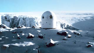
This project, by the US Coast and Geodetic Survey, sent four civilian observers from the Army Topographic Command to winter at Palmer Station along with this Wild BC-4 camera and its instrumentation shelter. The idea was that they would photograph a reflective satellite while 2 other stations did so simultaneously against the backdrop of stars. The film was sent back to Rockville, MD for analysis, and (eventually) an accurate determination of the camera position. Sort of an early GPS in reverse. The rest of the story, pictures, and papers are here.
Summer 1969-70
Another unique science project included bird egg collection (they were frozen for later study) and melt stream analysis
GWR completed and occupied; Seabee construction camp demobilized; effort includes extensive site cleanup
Minor fire in "trawler storage area" (current labs 6-7-8) (3/3), paint damage and one buckled wall panel
Winter 1970
OIC: LTJG Donald McLaughlin; population 10 (list and photos)
Winter science--Steve Shabica continued the Oregon State studies of intertidal ecology
Summer 1970-71
USCG icebreaker Westwind transfers 20,000 gallons of diesel fuel from OP to station
Major international volcanological expedition conducted to study recent Deception Island eruptions (the most violent eruption was 12/8
R/V Alpha Helix (about the size of Hero), calls at Palmer in support of penguin/cormorant studies (1/2 through 2/22); this Scripps project was not funded by NSF
OP science--studies continue on springtails and other plants/insects; and pond algae. UCD researchers living at OP forced to move out due to generator carbon monoxide problems
Winter 1971
OIC: LTJG Ernest Fenton; population 11 (list, photos and poem (!))
Winter science by Texas Tech--studies of insects and spiders
Summer 1971-72
Original BAS "Base N" hut (at OP site) destroyed by fire (12/28) during renovations by BAS personnel, a blowtorch ignited the attic.
Summer/winter project by UCD studies benthic foraminifera and plankton; summer field team includes Ted DeLaca
Another UCD project studies insect feeding rates by mixing cesium 134 with their food
Mary Alice McWhinnie makes her first visit to a U. S. Antarctic station--McMurdo (2/25) at the completion of an Eltanin cruise
Winter 1972
OIC: LCDR Paul Jacobs; population 13 (list and photo)
More winter science--Texas Tech arthropod studies continue
Summer 1972-73
2-man USGS team arrives via Argentine Twin Otter (11/30) to set up Doppler satellite tracking equipment. "TRANET station 196" was operational 12/8
3-man film crew from Image Associates with NSF grant films Peninsula logistics and science activities throughout December (a 7-1/2 minute documentary "South of Nearly Everywhere," part of an NSF "Encounters with Science" series, was released in early 1974)
Minnesota group studies leopard seals vs. Adelie penguins at OP-based field site (the leopard seals lost--19 animals were immobilized with drugs for study and tagging; 4 of these seals died from drug-related causes)
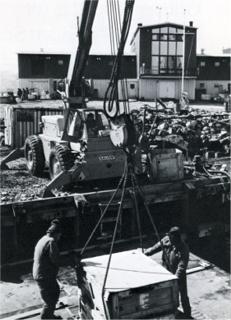
The Chilean Navy supply tug/tender Yelcho unloads cargo at the pier. The 205-foot, 1640-ton vessel was named after the earlier Chilean Navy cutter that rescued Shackleton's party from Elephant Island in 1916. Originally the USS Tekesta, built in 1943, it was bought by the Chilean navy in 1960. It was a frequent visitor to the station from the earliest days (1965) until it was placed out of service in 1996, decommissioned in 1998, and sunk in 1999 after serving as a target in joint Chilean-US naval exercises. Yelcho brought in supplies as seen here, hauled off scrap material for salvage, and also participated in the 1989 Bahia Paraiso cleanup (U. S. Navy photo from DF-73 cruisebook).
The R/V Hero encounters Jacques Cousteau's RV Calypso at Port Foster, Deception Island and bears witness to the death of the Calypso first mate (29 December).

The vessel made the trip to film for future television shows which would eventually become part of his 36-episode series The Undersea World of Jacques Cousteau, and footage would also appear in his later film Voyage to the Edge of the World. During one of Cousteau's videos of the venture he stated, "We are alone in Antarctica," while the Hero was moored close by but off camera. The first mate of Calypso, Michel Laval, was killed (29 December) after being struck by the tail rotor of the Calypso's helicopter...and was declared dead by Hero captain Pieter Lenie. The story (with video, of course), is here.
Australian sailor David Lewis just barely reaches Palmer halfway around on his solo circumnavigation of Antarctica in the 32' steel sailboat Ice Bird. When he reaches the pier (29 January) he ties up alongside Jacques Cousteau's RV Calypso(!)...that is his version of his arrival from his book Ice Bird...but there is another version here.
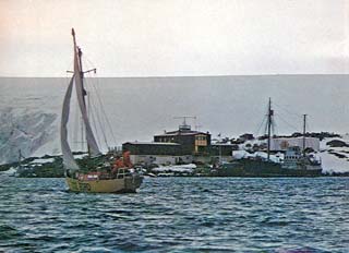
This photo is from just before his departure the following summer (12 December 1973); this time Hero is at the pier. David was dismasted 8-1/2 weeks before his arrival at Palmer (credit and more information). David's arrival occurred during Cousteau's film venture described above; I believe this was Calypso's only call at Palmer.
Cargo is delivered by the USNS Mirfak, a 266-foot ice-strengthened vessel that was small enough to use the pier using a pontoon carried from McMurdo, and left behind for future use (?)
Winter 1973
OIC: LT Lloyd Jukkola, population 15 (list and photo)
Winter science--UC Davis foraminifera studies continue, including extensive winter scuba diving program to study benthic mud communities; USGS satellite tracking operations proceed
Navy w/o crew due much of the repair work on Ice Bird in their spare time
Summer 1973-74
David Lewis (see above) arrives aboard the John Biscoe (10 November) to finish repairing his yacht and continue his journey)
Holmes & Narver assumes operation of Palmer Station (from the Navy); and Hero (from Hydrospace-Challenger, Inc.) (1 December) with new 5-year contract
Hero deploys OSU and Norwegian glaciology teams to Deception and Livingston Islands.
Case Western Reserve group studies bird blood at low temperatures
USGS group discontinues Doppler satellite tracking due to poor propagation
Winter 1974
Manager: Fernando Franca; population 9 (list and photo)
Hero homeport hurriedly switched from Punta Arenas to Ushuaia at the end of the season due to the changing political climate
Hero overhauled in Long Beach
Summer 1974-75
Several significant leopard seal incidents, including encounters with Ted DeLaca and Daren Laine (no harm no foul)
Trash dump "moved to a remote location"
First trip to Palmer by ornithologist Bill Fraser (1/11) as part of David Parmalee's Minnesota team studying gulls, petrels, skuas and terns
Winter 1975
Manager: Bill Lokey; population 10 (list and photo)
Minnesota ornithology program continues through the winter
Major winter generator surgery
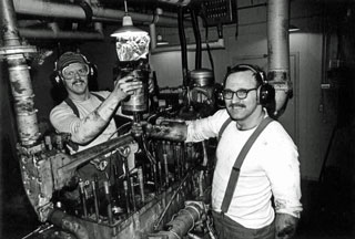
In one of the more interesting bits of power plant history, after some difficulty with both of the 342 generators, one of them was given some major surgery and put back to work on 3 cylinders for the end of the winter season. Here is manager Bill Lokey (left) and mechanic Warren Lincoln showing off their work. Reportedly it was Shane Williams' idea (thanks Gary Bennett)!
Continue to 1975-85 timeline